
New Jersey braces for significant snowfall: Town-by-town predictions for Tuesday
New Jersey is gearing up for a significant winter storm on February 11, 2025, with snow accumulations varying across the state. Residents are advised to stay informed and exercise caution during travel.

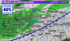
As New Jersey prepares for a significant winter storm on February 11, 2025, residents across the state are anticipating varying snow accumulations. The National Weather Service has issued advisories and warnings, urging caution due to expected hazardous travel conditions.
In northern regions, including areas like Newark, light snow is anticipated, with accumulations around one inch. Central parts of the state, such as Lakewood, are expected to receive between 2 to 5 inches of snow, accompanied by occasional snow showers. Southern regions, including Hamilton, are forecasted to experience heavier snowfall, with totals ranging from 4 to 6 inches.
Snowfall predictions by region
- Bergenfield: 2 inches
- Hackensack: 2 inches
- Hackettstown: 3 inches
- Harrison: 2 inches
- Hoboken: 2 inches
- Jersey City: 2 inches
- Lyndhurst: 2 inches
- Millburn: 3 inches
- Newark: 2 inches
- Paramus: 2 inches
- Ridgewood: 2 inches
- Secaucus: 2 inches
- Sommerville: 3 inches
- Sussex: 2 inches
- Wantage: 2 inches
- West Milford: 3 inches

Snowfall predictions for the whole New Jersey state. Photo: NJ.com.
The timing of this storm means that both Tuesday evening and Wednesday morning commutes could be dangerous, National Weather Service forecasters warn. It will be followed by another storm. "Another storm is expected to closely follow on the heels of the early week storm, impacting many of the same areas beginning on Wednesday," said AccuWeather Meteorologist, Alex Duffus. AccuWeather noted that some may not even notice a break in between before the next storm begins.
Safety precautions for New Jersey residents and travel advisories
The National Weather Service advises residents to exercise caution during travel, as road conditions may become slippery. It's recommended to monitor local weather updates and plan commutes accordingly.
- Stay Informed: Regularly check local weather forecasts for updates.
- Emergency Kit: Prepare an emergency kit with essentials such as flashlights, batteries and non-perishable food items.
- Vehicle Maintenance: Ensure your vehicle is equipped with necessary supplies, including a snow shovel, ice scraper and blankets.

People preparing themselves for the incoming snowfall. Photo: www.northjersey.com.
The aforementioned snowfall is expected to start at around 7 p.m. on Tuesday evening, according to National Weather Service meteorologist, Bryan Ramsey. "Accumulation will likely drop off as you go north, but increase in areas in the south. A few hours after daybreak is when the snow should be ending," said Ramsey.
Forecasters are tracking a third storm this weekend. It's too early for details, but National Weather Service forecasters predict another quick shot of snow that turns into a wintry mix and then into plain rain.