
Massachusetts faces some midweek weather changes, with snow and rain expected to arrive in Boston
A changing atmospheric system will bring varied precipitation across the state, impacting travel and daily routines. While inland areas prepare for accumulation, coastal regions may experience slippery, slushy conditions. Residents should stay alert as the forecast develops.

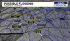
Residents of Massachusetts must prepare for varying weather as midweek storms bring intensity to the region. Some areas will experience snowfall, while others may see heavy rain, creating potential travel disruptions and slippery roads. With rapidly fluctuating temperatures, icy patches and reduced visibility could contribute to the challenges.
A developing system will move in by Wednesday evening, delivering the first round of precipitation. Western and central of the Bay State are likely to see snow accumulation, while coastal sectors, including the city known for its historic winters, may experience rain or mixed precipitation. Meteorologists advise staying updated, as shifting temperatures and wind patterns could affect conditions.
Which areas will see the most snowfall?
The heaviest tempest is expected in higher elevations, particularly in the western and central parts of the state. Worcester County and the Berkshires could receive several inches, making roads slick and hazardous.
Meanwhile, lower-lying zones and locations closer to the shore are more likely to experience a wintry mix. In the capital, precipitation may start as snow before turning to rain overnight, creating slushy, wet roads that could slow commuters Thursday morning.
How will this storm impact travel?
Snow-covered roads and freezing temperatures could make driving conditions dangerous, especially in territories where untreated surfaces turn icy. Officials are preparing to deploy plows and salt trucks to keep highways clear, but drivers should remain cautious.
Air travel may also be affected, with possible delays at Logan International Airport due to changing conditions. Travelers are advised to check with airlines for updates. Public transportation users should allow extra time as crews work to maintain safe routes.

Braving the cold as snow blankets Massachusetts, bringing a true winter scene to the streets. Photo: Mass Live
What to expect moving forward
The storm is expected to move out by early Thursday, but lingering cold could leave icy patches on the roads and sidewalks. Motorists and pedestrians should exercise caution in the morning.
Meteorologists will continue tracking the system for any last-minute changes in snowfall totals or timing. Residents should stay informed through local forecasts and National Weather Service updates, while taking precautions like dressing warmly and allowing extra travel time.